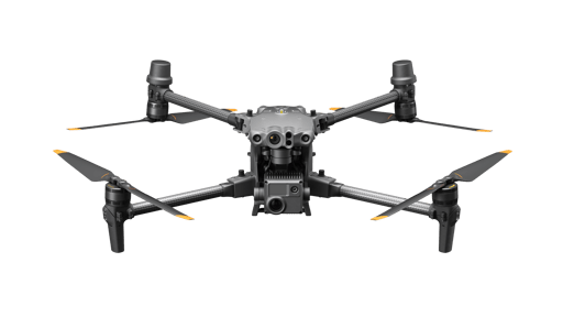
Features
- Compact and transportable design
- Multiple high-performance sensors integrated into one camera payload
- Remote operation capabilities
- Weather-resistant construction
- Obstacle avoidance sensors
- Extended flight time with self-heating battery technology
- Data security protocols including offline updates and local data mode
Specifications
| Camera | 48 megapixel 1/2” CMOS sensor zoom camera with 5x to 16x optical zoom |
| Weight | 3.7 kg take-off weight |
| Flight Time | 41 minutes |
| Charging Case | BS30 charging case for fast battery charging |
| Thermal Camera | 640x512 px radiometric thermal camera (M30T version) |
| Remote Controller | DJI RC Plus with 7-inch HD screen |
| Ingress Protection | IP55 |
| Operating Temperature | -20° C to 50° C |
A commercial drone designed for professional use, offering features for various operational needs.
Project Ideas
Business
Aerial Surveying and Mapping
Offer aerial surveying and mapping services for construction, agriculture, and environmental monitoring. The drone's high-resolution camera and extended flight time make it ideal for capturing large areas in detail.
Security and Surveillance
Provide security and surveillance services for events, construction sites, or private properties. The drone's remote operation and obstacle avoidance features allow for efficient monitoring of large areas.
Inspection Services
Offer inspection services for infrastructure such as bridges, pipelines, and power lines. The drone's high-performance sensors and zoom capabilities can identify potential issues without the need for manual inspections.
Agricultural Monitoring
Develop a business around precision agriculture by using the drone to monitor crop health, irrigation systems, and soil conditions. The thermal camera and other sensors can provide valuable data to farmers, helping them optimize their operations.
Event Photography and Videography
Start a service offering aerial photography and videography for events such as weddings, concerts, and sports games. The drone's high-resolution camera and ability to capture unique angles can provide clients with memorable, high-quality footage.
Creative
Aerial Art Installation
Utilize the drone to create stunning aerial light shows or art installations for public events. The high-performance sensors can be used to synchronize the drone's movements with music and other visual elements, creating an immersive experience.
Nature Documentation
Capture high-resolution, close-up footage of wildlife and natural landscapes. With its extended flight time and weather-resistant construction, the drone can document seasonal changes, animal behaviors, and more, providing valuable content for educational purposes.
Architectural Photography
Use the drone to take unique, high-quality photographs of architectural structures. The multiple sensors and zoom capabilities allow for detailed shots from various angles, which can be used for portfolios, marketing materials, or even art exhibitions.
Virtual Tours
Create interactive virtual tours for real estate, tourism, or historical sites. The drone's camera can capture panoramic views and detailed close-ups, which can be stitched together to offer a comprehensive, immersive experience for viewers.
Disaster Simulation Training
Design simulated disaster scenarios for training purposes using the drone's various sensors. Capture detailed footage and data for first responders to practice and improve their response strategies in a controlled environment.